


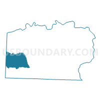
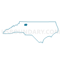
Voting District NBCK, Yadkin County, North Carolina
About
Outline

Summary
| Unique Area Identifier | 641888 |
| Name | Voting District NBCK |
| County | Yadkin County |
| State | North Carolina |
| Area (square miles) | 22.51 |
| Land Area (square miles) | 22.44 |
| Water Area (square miles) | 0.07 |
| % of Land Area | 99.68 |
| % of Water Area | 0.32 |
| Latitude of the Internal Point | 36.12173720 |
| Longtitude of the Internal Point | -80.82757820 |
Maps

Graphs
Select a template below for downloading or customizing gragh for Voting District NBCK, Yadkin County, North Carolina


Neighbors
Neighoring Voting District (by Name) Neighboring Voting District on the Map
- Voting District 117, Wilkes County, NC
- Voting District 122, Wilkes County, NC
- Voting District DCRK, Yadkin County, NC
- Voting District SBCK, Yadkin County, NC
- Voting District SKNB, Yadkin County, NC
Top 10 Neighboring County Subdivision (by Population) Neighboring County Subdivision on the Map
- Deep Creek township, Yadkin County, NC (3,326)
- North Buck Shoals township, Yadkin County, NC (2,348)
- South Knobs township, Yadkin County, NC (1,804)
- New Castle township, Wilkes County, NC (1,740)
- South Buck Shoals township, Yadkin County, NC (1,368)
- Somers township, Wilkes County, NC (1,077)
Top 10 Neighboring Unified School District (by Population) Neighboring Unified School District on the Map
Top 10 Neighboring State Legislative District Lower Chamber (by Population) Neighboring State Legislative District Lower Chamber on the Map
Top 10 Neighboring State Legislative District Upper Chamber (by Population) Neighboring State Legislative District Upper Chamber on the Map
Top 10 Neighboring 111th Congressional District (by Population) Neighboring 111th Congressional District on the Map
Top 10 Neighboring Census Tract (by Population) Neighboring Census Tract on the Map
- Census Tract 9612, Wilkes County, NC (7,171)
- Census Tract 504, Yadkin County, NC (6,729)
- Census Tract 503, Yadkin County, NC (5,964)